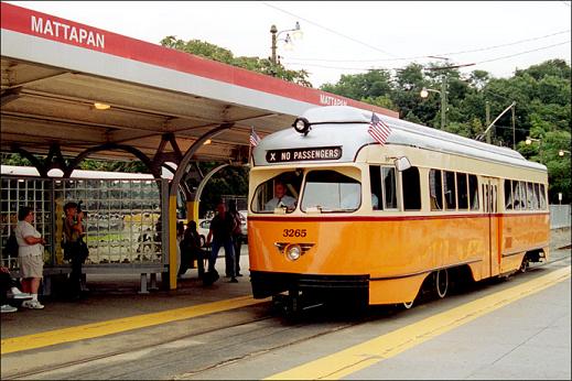
 Boston Mattapan-Ashmont PCC streetcar
(Photo: MBTA)
· "Bus Rapid Transit" Analyses · Political Campaigns for Light Rail Related Links
Light Rail Now Project can be contacted at: Light Rail Now! |
Light Rail Now! NewsLog Produced by the Light Rail Now! Publication Team This news feature provides an ongoing Weblog of particularly significant developments in public transportation and rail transit. 29 December 2007
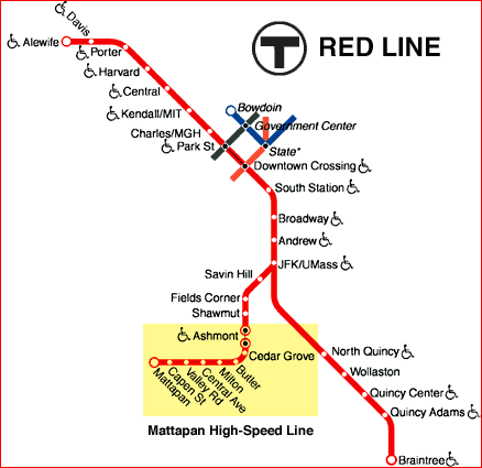
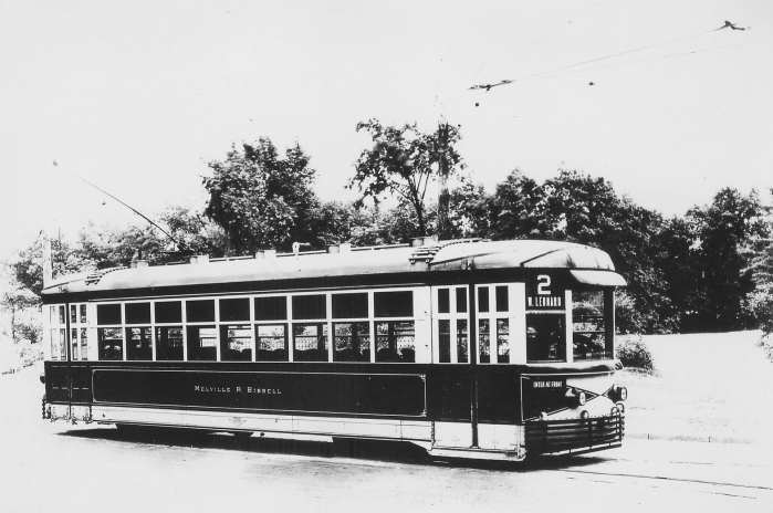
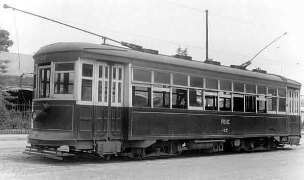
Boston: After an 18-month makeover, Boston's venerable High Speed trolley line connecting the southern suburbs of Mattapan and Ashmont re-opened for public service on December 22nd. Boston's Mattapan-Ashmont trolley line and the 15-Girard line in Philadelphia are the last "legacy" US light rail transit (LRT) lines still operating Art Deco-era PCC streetcars in regular scheduled service. (The Presidents Conference Committee or PCC car – see photo further below – was the high-performance streetcar designed by a committee established by transit company top managers in the 1930s, and subsequently licensed to a number of streetcar manufacturers in the USA and abroad, where they were produced in the thousands, mainly in the 1940s and 1950s. Today, PCCs are also operated on San Francisco's F-Line, and in Kenosha, Wisconsin, but these are more recently installed heritage streetcar systems.) Communities surrounding the Mattapan-Ashmont route have been clamoring for restortion of the rail service. As an article on the NYCSubway.org website relates, the Mattapan-Ashmont line "was built on a railroad right of way to help speed trolley cars into Boston from the Dorchester area. At only 2.2 miles the line is one of the shortest existing trolley lines, but it is surprisingly scenic considering its location on the border of a major city." The major function of the line is to serve as a feeder to the major Red Line rapid transit station at Ashmont. Besides its termini at Mattapan and Ashmont, the line has 6 intermediate stops – for a total of 8 stations.
In June 2006, the Massachusetts Bay Transportation Authority (MBTA) suspended service on the Mattapan-Ashmont High Speed Line to facilitate "the complete reconstruction of the terminals at Ashmont and Mattapan, which both date from the late 1920s", according to an article on the Railroad.net website (December 2002, updated June 2006).
While the line was still closed for rehab, an article in the Weekly Dig (Boston-area "alternative" paper, 23 Aug. 2007) additionally noted that the PCCs were being retrofitted with air conditioning, and many of the electric poles supporting the overhead contact system (OCS) were being replaced. The paper also reported that In lieu of the PCC trolleys, "the T has been running a temporary 'trolley shuttle' (an MBTA bus)" As a result, "Neighbors have become disgruntled; some worry that the 'temporary shutdown' might become permanent." Fortunately, it now appears that these fears have come to naught. The Dig also notes strong community loyalty to the trolley service, with persistent resistance to MBTA efforts to replace it with a "heavy" rapid transit Red Line extension (1960s) and then with buses (1981). The issue arose again, says the paper, when,
Another reason the Mattapan-Ashmont line has endured as a trolley operation, the Weekly
Dig relates, is the very durability of the PCC cars themselves:
"Despite their considerable age, the PCCs are still efficient and cost-effective" writes the paper.
"The line tends to work better with those cars than the modern equipment" says Gerry O'Regan,
treasurer of the Boston Street Railway Association (BSRA).
The article continues with an additional explanation of the advantage of PCCs:
Be that as it may, fans of the Mattapan-Ashmont High Speed trolley line are joyous that the service has resumed. "The MBTA is making like Santa Claus ... " writes Caroline Roberts in the Bostonist alternative publication. "Now they've announced that the trolley between the Ashmont and Mattapan stops is back in business." For additional information on the Mattapan-Ashmont High Speed line, see the following online sources: Light Rail Now! NewsLog URL: http://www.lightrailnow.org/news/n_newslog2007q4.htm#BOS_20071229 Updated 2007/12/29 28 December 2007
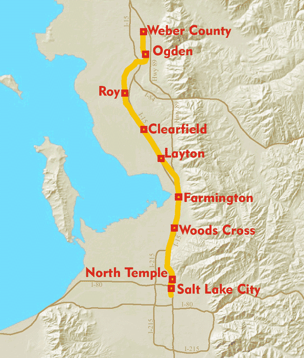
Salt Lake City: Yet another new rail transit service is heading toward startup. The Salt Lake City-area FrontRunner regional passenger rail (RPR, "commuter rail") service is on schedule for launch in the spring of 2008 by the Utah Transit Authority (UTA), to run initially from Salt Lake City to the exurb of Pleasant View in Weber County (just north of Ogden). On 25 October 2007, according to a report from KUTV-TV News, a FrontRunner train made its first run to demonstrate how the rail service will carry passengers from Weber County to Salt Lake City "when it opens to the public in a few months." UTA allowed members of the media, various public officials, and members of the community to ride three Bombardier-built bi-level (double-decker) RPR coaches on a 15-mile trek between the exurbs of Woods Cross and Kaysville before returning to Woods Cross, reaching a top speed of 79 miles per hour during the initial run.
FrontRunner trains feature a variety of amenities, including on-board restrooms and Wi-Fi Internet service (available at no cost). UTA plans to operate FrontRunner trains every 30 minutes between 05:00 and 23:00 Monday-Friday; and 07:30 to 23:00 on Saturday (with no service on Sundays). UTA plans to begin operating the full 44-mile FrontRunner line by November 2008 (see map below). By 2025, the agency projects weekday ridership of 12,500.
Per the agency's Full Funding Grant Agreement with the US Department of Transportation, capital investment cost of the FrontRunner project is $489 million – calculating to about $11 million per mile. Interconnectivity is a key aspect of the design of Frontrunner. UTA's Intermodal Hub, located behind the Union Pacific main station on Rio Grande Street (just south of the Gateway), will serve as the main transfer station for commuters transferring between FrontRunner and UTA's Trax light rail transit system. "For example," notes the KUTV News report, "someone commuting from Weber County to downtown Salt Lake City will exit the FrontRunner train at the Intermodal Hub and board a Trax train that serves the downtown/University/Sandy area." Light Rail Now! NewsLog URL: http://www.lightrailnow.org/news/n_newslog2007q4.htm#SLC_20071228 Updated 2007/12/28 21 December 2007
Miami: Miami's somewhat sputtering, on-again, off-again central-city streetcar project has finally got a major jumpstart as both the Miami City Commission and Miami-Dade County commissioners backed what the Miami Herald (Dec. 18th) described as "a multibillion-dollar deal to build a baseball stadium, downtown streetcar, museum campus and an underwater tunnel to the Port of Miami." According to a Fact Sheet from the City of Miami's Streetcar Project,
According to the Fact Sheet, capital investment for the streetcar project, including contingency, is estimated at US$200 million (in 2006 dollars – roughly $207 million in 2007 dollars). Operations and maintenance (O&M) costs are estimated at $7.9 million annually. The capital investment is not exclusively for the streetcar project – as the Fact Sheet notes, the streetcar project "is included in the Citys Capital Improvement Program", and will incorporate "reconstruction, resurfacing, sidewalk repair, and traffic control for public streets in Downtown Miami." To finance the system, Miami Mayor Manny Diaz apparently has cobbled together a plan to use two Community Redevelopment Agency districts as funding vehicles to jumpstart the streetcar and a handful of of other "legacy-building" projects in the city, according to a Miami Herald Dec. 16th editorial. Financing details are somewhat blurry from the flurry of news reports, but according to NBC6 News (December 13th), the City of Miami will "pitch in $488 million to get the performing arts center out of debt and implement the streetcar," described as "a new mode of transportation that will connect Miami's urbanized areas." Added to that, says the Miami Herald (Dec. 18th), will be $20 million that will come out of the county's share. Justifying the streetcar, the City of Miami's Fact Sheet expects that the streetcar service "will improve circulation for a multiplicity of short trips within the study area...." In addition, City planners also expect the streetcar system to service "many of the areas now experiencing largescale redevelopment" that are not currently served directly either by Miami's Metrorail (elevated) rapid transit system or the Metromover automated peoplemover system.
"Why not use a bus instead of a streetcar?" asks the Fact Sheet.
A supporter of the streetcar project passionately summed up the anticipated benefits of the new rail transit system:
Light Rail Now! NewsLog URL: http://www.lightrailnow.org/news/n_newslog2007q4.htm#MIA_20071221 Updated 2007/12/21 15 December 2007
Charlotte: Less than two weeks after starting revenue service, Charlotte's new Lynx light rail transit (LRT) South line has exceeded its projected ridership target. Charlotte Area Transit System (CATS) had originally forecast an average ridership of 9,100 weekday trips in the line's first year of operation. However, CATS said the average daily ridership in the first seven days of LRT service after the agency began charging fares was 12,300 (reported in the Charlotte Observer, 9 Dec. 2007). That figure is 35% over the forecast ridership level. After a slow start, ridership began climbing. On the first day of revenue service (Monday, Nov. 26th) Lynx recorded 6,700 rider-trips. That climbed to just over 8,000 on Nov. 27th. CATS chief executive Ron Tober told the Charlotte Observer that the high ridership for the first week was due to "more people than expected riding the train during off-peak times." Another sign of ridership growth is the use of park & ride facilities. "Many park-and-ride lots still have few cars" note the Observer. "But at the line's southern end, at the Interstate 485/South Boulevard and Sharon Road West stations, the number of cars is increasing." As the news article relates,
And, notes the paper, "Getting commuters out of their cars is a key goal for CATS. Not only are park-and-ride customers most likely new transit users, they usually take longer train trips – getting cars off the road and reducing pollution." One problem that might have been constraining even greater public use of the new LRT service is "malfunctioning ticket kiosks" (ticket vending machines, commonly known as TVMs), which, says the Observer "are still bothering riders." As a result, "Technicians from Atlanta-based ACS, the vendor, have been trying to correct glitches with the printers." Despite such minor glitches public acceptance of the new rail service has generally been enthusiastic. A Nov 27th article in the Observer quoted the positive assessment of a number of new riders – even, in some cases, with longer trip times than by car! Light Rail Now! NewsLog URL: http://www.lightrailnow.org/news/n_newslog2007q4.htm#CHA_20071215 Updated 2007/12/15 13 December 2007
Grand Rapids: Grand Rapids, Michigan – Interest in light rail is moving forward with a $360,000 feasibility evaluation of a proposed streetcar starter line being conducted by the consulting firm of DMJM Harris. Being studied is "a 2.4-mi. (3.9 km) downtown streetcar circulator that would connect Van Andel Arena, the DeVos Place convention center, museums and other entertainment venues", according to a report in Rail Transit Online (November 2007). The streetcar would supplement what is currently intended to be the city's "primary" line-haul transit mode, a "bus rapid transit" project serving the Division Avenue corridor. According to a report in the Grand Rapids Press (25 October 2007), the streetcar route would take the line north and south on Monroe, Ottawa, and Ionia Avenues NW, stretching from the Sixth Street Bridge south, almost all the way to Wealthy Street SW. As the Press relates, enthusiasm for the streetcar plan comes mainly from a group of "well-connected local business leaders and politicians", including Grand Rapids Mayor George Heartwell, former Mayor John Logie, and Wyoming Mayor Carol Sheets. "In November," reports the paper, "they were among local leaders who flew to Portland, Ore., to study that city's streetcars. The intent is to duplicate Portland's system, which was paid for with mostly private funding and parking revenues." Preliminary investment cost of the streetcar proposal is estimated to carry a price tag of at least $69 million. However, the plan "has strong support from political and business leaders who believe it will spur development" reports the Press. "There's a sparkle, but, at the same time, there's cautious optimism" Jim Fetzer, director of development for the local transit system (The Rapid), told the newspaper. "We want to get the facts to make sure it's something the community should explore and invest in." Projected to take eight months, the study will examine potential ridership, development potential, funding sources, and a fare structure for the streetcar operation. According to a brief summary on Dave's Railpix, the Transit Holocaust came relatively early to Grand Rapids, when, in 1934, the city became only the second city in the USA to abandon electric rail service entirely, replacing it with motor buses. The streetcar era in Grand Rapids came to an end on 23 August 1935, when the last streetcar made a final run along the city's Cherry Street route.
Light Rail Now! NewsLog URL: http://www.lightrailnow.org/news/n_newslog2007q4.htm#GRR_20071213 Updated 2007/12/13 8 December 2007
Seattle: Get ready for the launch of America's newest electric light rail transit line. Seattle's 1.3-mile (2.1-km) South Lake Union Streetcar line will start operations on 12 December, in an event commemorated by city and state elected officials in an official opening ceremony at the Westlake Hub, located at Westlake Avenue and Olive Way. As our November 2006 article Seattle: USA's latest new-start streetcar project under way noted, Seattle's new streetcar starter line represents "More evidence of the growing popularity of the electric streetcar comeback ...."
Annual ridership for the first year has been forecast at 300,000 passenger-trips – averaging nearly 1,000 rider-trips per weekday. Throughout the month of December, passengers using the new streetcar service can ride for free.
Even though the streetcar system hasn't even started up yet, expansion of streetcar service has
already been proposed in a special report by University of Washington professors Anne Vernez
Moudon and Mark Hallenbeck – see: The $40,000 study, performed at the request of the Urban League and the Seattle Streetcar Alliance, identified five other Seattle neighborhoods that would provide what the Seattle Times (6 December 2007) called "ideal conditions" for more streetcar lines:
For Seattle Mayor Greg Nickels, the streetcar system "is an investment in the future of Seattle."
Light Rail Now! NewsLog URL: http://www.lightrailnow.org/news/n_newslog2007q4.htm#SEA_20071208 Updated 2007/12/08 20 November 2007
Roanoke: Could electric light rail public transportation return to Roanoke, Virginia after more than 60 years? A proposal to build a light rail transit (LRT) streetcar line is gaining momentum in Roanoke, a city of 95,000 people, where streetcars once carried up to 24 million riders a year before they were shut down and the tracks torn out in 1948 (see photo, below). The current proposal is for a 1.3-mile (2.1-km) streetcar route along Jefferson Street from Norfolk Avenue downtown to Reserve Avenue and the developing Carilion Biomedical Center.
Community and political support for the project is growing, according to a brief article in Rail Transit Online (August 2007). This article also reports that Wilbur Smith Associates conducted a preliminary feasibility study in 2004, which estimated capital costs of approximately $17 million ($13 to $14 million per mile or $8 to $9 million per km) and annual operating costs of $275,000. in an article in the Roanoke Times of 13 January 2006, Councilmember Beverly Fitzpatrick, who spearheaded the project, had told the paper that "[The study] suggests that the cost for the city would be around $8 million, with the rest (another $10 million) from federal transportation funds. A more in-depth study needs to be done and we are working to find state funding to pay for that information." More recently, in a Roanoke Times op-ed essay (4 Nov. 2007.), Chris Henry underscores that "Light rail is an attractive option because it is fast, quiet, green and cheap in comparison to new roads. ... A permanent trolley system connecting downtown Roanoke to the new biomedical center is far from a bad idea." Valley Metro, the local transit provider, is taking the lead on the project. According to Dave Morgan of Valley Metro, "The Greater Roanoke Transit Company (GRTC) which operates both Valley Metro and the Smart Way bus services is currently gathering data to determine the possibility of re-instating streetcars along the Jefferson corridor. We have met with the Federal Transit Administration (FTA) and the Virginia Department of Rail and Public Transportation to discuss this issue and have received a grant to assist with this evaluation process. We are also working with our elected officials to gain Federal support for this project. But Federal funding has been applied for at this time." [E-mail correspondence, 16 Nov. 2007] Valley Metro plans to initially run three cars. The streetcars would either be restored heritage ("vintage") cars or replicas of the older cars, but they would also be air-conditioned and handicapped- accessible. [Tom Angleberger, Roanoke Times, 23 Jan. 2006] The system would not be in operation before 2011, according to Bob Fetzer, a developer and former chairman of Downtown Roanoke inc. "if we could get that process moving faster, it would be great" Fetzer told the Roanoke Times (26 May 2007). Councilman Fitzpatrick has dreams of expansion in the future, from downtown to Crystal Spring. "A light rail system in Roanoke would require a substantial capital investment, but other systems have been made feasible through public/private partnerships," writes Chris Henry in the Roanoke Times (4 Nov. 2007). "The additional tax revenue realized through denser economic development along light rail lines combined with user-fees would ensure that taxes need not be raised." "it is time for Roanoke to look to the future. Development follows transit, not the other way around" Henry concluded. [òSP] Light Rail Now! NewsLog URL: http://www.lightrailnow.org/news/n_newslog2007q4.htm#ROA_20071120 Updated 2007/11/20 17 November 2007
Little Rock: Extend Little Rock's quaint, heritage-style River Rail streetcar line to the city's airport? Yep – that's exactly what local planners and decisionmakers are now considering. "A River Rail extension to Little Rockìs airport is moving forward as local governments look for a consultant to map out a route and determine a cost for branching out from downtown" reports the Arkansas Democrat-Gazette (27 October 2007), which notes that "The airportìs terminal is about three miles from the streetcarìs easternmost stop near the Clinton Presidential Library and Heifer international." The article goes on to relate that
Ïitìs really as much of a route study as it is a feasibility studyó, Pulaski County Judge Buddy Villines told the paper. ÏThere was a study in the late 1980s that said going from downtown to the airport was feasible back then. if we could lay out where the route is going it would give us an idea of what the cost will be.ó According to Villines, the airport rail transit study would consider alternative routes, the use of new track or existing freight rail track, and costs. Results could be forthcoming in about six months. As Jim McKenzie, Metroplanìs executive director, told the paper, the planning agency
ÏThe [extensionìs] cost will be dictated by the route chosenó McKenzie said. ÏWe wonìt know the route until we get into it.ó The River Rail streetcar originally opened its 2.5-mile, $20 million first phase in November 2004 on two loops in Little Rock and North Little Rock, connected by a track across the Main Street Bridge over the Arkansas River. A half-mile, $9 million second phase, extending service to the Clinton Library and Heifer international east of the interstate 30 freeway, opened in February 2007, expanding the system to a total of about 3.0 miles. That Clinton Library line was designed for eventual extension to the airport, according to the Arkansas Democrat-Gazette article. Ïitìs been in the plans ever since the idea for River Rail first became a realityó explained Betty Wineland, executive director for Central Arkansas Transit Authority, which operates River Rail. ÏJust where it was going to fit into the expansion, we really didnìt know.ó The two cities and the county were partners in building the first two phases of the $29 million River Rail system and will equally share in subsidizing about $689,000 for operating expenses this year, the paper reports. "Federal funding paid for 80 percent of the start-up and expansion. The same formula would apply for the next phase" notes the article. As the paper points out, because the second phase is entirely in Little Rock, North Little Rock has first rights to determining the next extension, "under terms of project financing agreed to by the two cities." However, Mayor Patrick Hays is saying that North Little Rock would forfeit its priority rights "if it means building an airport extension." ÏThere is still some development iìd like to see materialize before i would suggest we exercise our option,ó Hays said. ÏAnd i think it would benefit us a great deal to have downtown connection from our city to the airport.ó And the airport already has incorporated some infrastructural design in anticipation, according to Philip Launius, a spokesman for the airport. He noted that when the airport built a parking deck in 2001, plans incorporated ways to accommodate a River Rail link. While the airport has never surveyed airline passengers to measure interest in a streetcar extension, Launius predicted that such a service would likely attract passengers. Ïit would be an interesting sort of way to get to and from hereó Launius told the Democrat-Gazette. ÏObviously, local passengers would have their vehicles here. The people from out-of-town might enjoy it and might like to do it because it would be a different thing to do.ó The extension could use current streetcars and continue onto the existing downtown tracks, VATA's Wineland said. Streetcars can reach speeds of 40 miles an hour, but move slowly now because most track runs along busy downtown streets. Because it would combine the operating features of conventional streetcar with higher, rapid-transit- like operating speed, the River Rail airport extension could be considered a version of Rapid Streetcar – as described in the Light Rail Now article Rapid Streetcar: Rescaling Design and Cost for More Affordable Light Rail Transit. Ïi wouldnìt think people leaving the airport would necessarily want to transferó Wineland said. ÏWe might want to modify the interior [of additional trolleys] to have areas for luggage, but we basically could use the same cars.ó According to figures provided by Wineland, River Rail averaged 12,035 passengers monthly running three streetcars at a time through the first nine months of this year. Since it opened three years ago, streetcars havecarried about 445,000 riders. While weekday ridership is modest, passengers tend to swarm aboard the streetcars during peak-traffic downtown events and during conventions. ÏRight now it is set up for primarily for the tourist tradeó Metroplan's McKenzie told the paper. ÏBut the other thing we had hoped would happen is happening and that is weìre getting a significant amount of redevelopment along the rail line. ÏSo from the development angle, itìs done exactly what it was intended to do. And it is supporting the tourist economy, which is no small contribution to the regional economy here.ó Light Rail Now! NewsLog URL: http://www.lightrailnow.org/news/n_newslog2007q4.htm#LR_20071117 Updated 2007/11/17 15 November 2007 Houston's MetroRail (LRT) breaks record with 40 million boardings Houston Metro celebrated a major milestone in the second week of November (2007) when it carried its 40 millionth boarding passenger rider on the MetroRail light rail transit (LRT) system. "How big is that number?" asks a Metro news release. "itìs about the population of Poland; or, Reliant Stadium filled to capacity 560 times." That makes the MetroRail LRT "the most successful light rail line in the country," says Metro, pointing out that the 7.5-mile line "carries about 45,000 boardings each weekday – a number METRO didnìt expect to achieve until 2020." "The success of this line goes beyond anything we anticipated and proves that Houstonians do ride the rail, finding it a valuable way to get to work, weekend outings and sporting eventsó said Metro's president and CEO Frank Wilson. While MetroRail officially started operating on 1 January 2004, by February 2006 it had already reached its 20 millionth boarding passenger. That means that MetroRail has already doubled its ridership in a little over 20 months. Since its opening, Metro's news release points out, "METRORail has spawned new businesses along the line and allowed METRO to retool its bus system to remove 600 buses from downtown streets each day." Also, as the Light Rail Now article Houston Metro dumps "BRT", reinstates light rail transit plan in 5 corridors points out, Metro's Board of Directors recently scuttled plans to substitute "bus rapid transit" ("BRT") in four corridors voters had previously approved for LRT. instead, the board approved the expansion of the light rail system to those and one additional corridor – a total of five new corridors. "Construction on these will begin next year" promises the news release. in a related development, the Houston-Galveston Area Council (the regional metropolitan planning organization, or MPO) released its 2007 Transit Onboard Survey, which reported that:
Light Rail Now! NewsLog URL: http://www.lightrailnow.org/news/n_newslog2007q4.htm#HOU_20071104 Updated 2007/11/04 7 November 2007
New Orleans: The New Orleans Regional Transit Authority (RTA) has announced that beginning Sunday, 11 November 2007, streetcar service will be restored along the downtown half of the St. Charles Avenue line.
Restoration of this segment of the St. Charles streetcar line is the fruit of considerable effort and investment in rebuilding the infrastructure following Hurricane Katrina, particularly the devastating flood. For over a year, RTA has been replacing the St. Charles line's electric power distribution system, including the installation of three new $1 million electrical substations, plus hanging a new overhead contact system (OCS, "overhead wires"). Both trolley wires and feeder cables were torn apart by high winds and falling tree limbs during Katrina. According to an article in Trains magazine (Oct. 4th), contractors have been replacing most of the 560 OCS poles along the route. Rolling stock remains a problem since all but one of the distinctive bright-red PT-2000 heritager-style streetcars, fabricated by a partnership of RTA with Brookville Equipment Corp., were catastrophically damaged in the flood. However, the 35 original, historic Perley Thomas streetcars used on the St. Charles line survived Katrina because they were stored on high ground inside the Carrollton Station carbarn. These cars have been deployed on the Canal and Riverfront lines as temporary replacements for the PT-2000 cars. For the new St. Charles service, five streetcars are assigned to the route with additional ones available if needed. Four buses will provide supplemental service on the line after the opening. "New Orleanians, as well as visitors, have waited over two years for the return of the St. Charles Streetcar to the uptown area" says RTA in its release. "The renewed excitement and anticipation has been visible on the smiling faces of motorists and pedestrians as they glimpsed test runs of the streetcars along the Avenue during the weeks of October." An opening ceremony for the restored route is tentatively scheduled for Saturday, November 10 at 14:00. Passengers will ride free from the end of the ceremony until 17:00 in the afternoon. On Nov. 11th, the first streetcar will leave St. Charles and Common at 05:27 in the morning. Light Rail Now! NewsLog URL: http://www.lightrailnow.org/news/n_newslog2007q4.htm#NO_20071107 Updated 2007/11/07 4 November 2007 Houston Metro dumps "BRT", reinstates light rail transit plan in 5 corridors in a startling change of course, on 18 October 2007 the board of Houston Metro voted not only to proceed with a new east-west University light rail line with part of its route on Richmond Ave. (an issue under debate for over a year), but also to reinstate light rail transit (LRT) in all four of the other corridors that had previously been downgraded to "Bus Rapid Transit" ("BRT") after anti-transit US Representatives Tom DeLay and John Culberson, and the Federal Transit Administration (FTA), colluded to force this change in the voter-approved light rail system plan. (See Houston: Metro dumps MetroRail expansion plan, substitutes "BRT".) As Metro president and CEO Frank Wilson announced, changes in FTA rules for evaluating transit projects have improved the cost-effectiveness scores for Metro's planned North and Southeast lines above the minimum levels for funding. As a result, he said, Metro no longer will need to resort to the less expensive "BRT" alternative, and can proceed to install the LRT lines that voters originally approved and had been promised (reported in Houston Chronicle, 26 Oct. 2007.) The reinstatement of LRT was hailed by the Chronicle editors (as well as many others in the community) as "good news". "Metro's decision for rail in five corridors means the countdown to Houston's transit future starts now" proclaimed the paper's editorial (Oct. 20th).
As Metro chairman David Wolff explained to the Chronicle, the FTA "changed some of their ridership projection criteria to make these lines more favorable if we did them as rail." Furthermore, "They were willing to look at this as a system rather than as individual free-standing lines, and to recognize that if you build a system, you're going to generate more ridership than if you are doing one single line." The decision to route the west side of the University LRT line on Richmond Avenue culminated long and intense controversy and implicitly repudiated the opposition of US Congressman John Culberson, an extremist-rightwing Republican, who had pushed a far less feasible and more expensive alternative route. The decision was also a major victory for dozens of neighborhood residents and business owners along Richmond who had clamored for the LRT line (while Culberson backed a small minority that opposed it). As reported by the Chronicle (Oct. 20th), the approved route for the west side of the University line will take LRT down Richmond to Cummins, where it will jog south to Westpark for the remainder of its route to the Hillcroft Transit Center. On the east side of the University corridor, the LRT line would be routed down Wheeler to Texas Southern University and then on to Alabama, with a station at the University of Houston. A connection to the Eastwood Transit Center would be made via the Southeast light rail line. Despite the opposition from Republican Rep. Culberson, the Chronicle noted,
The paper also notes that the decision to reinstate LRT for the urban area's central mass transit network provides an array of advantages:
(it should be noted that LRT is not necessarily "more expensive" than buses – even with capital investment costs included. See: "Free" buses vs. "expensive" rail?.) The reinstatement of LRT underscores another issue: it seems unlikely that Metro would have made this change if "BRT" had all the supposed "advantages" claimed and ballyhooed by the highway and motor vehicle lobby, "BRT" promoters, and the brigade of anti-rail partisans familiar to almost every urban area's "Transit War" over rubber vs. rail. if "BRT" were so much more cost-effective, attractive to passengers, and so on, as these critics have claimed, would it really make sense that Metro would rush to reinstate LRT for these corridors, even in the face of federal approval of the "BRT" substitution? The Chronicle's Oct. 20th editorial concludes with the observations that
Transit advocates can certainly say "Amen" to that! Light Rail Now! NewsLog URL: http://www.lightrailnow.org/news/n_newslog2007q4.htm#HOU_20071104 Updated 2007/11/04 13 October 2007
Charlotte: With a November 6th referendum on Charlotte-area public transit rapidly approaching, the pro-transit campaign just got a significant boost. The Black Political Caucus of Charlotte-Mecklenburg voted on October 7th "to endorse efforts to keep the county's half-cent sales tax for mass transit", according to a news report in the Charlotte Observer (8 October 2007). As the article detailed,
The Black Caucus vote represents a major step forwards for the public transit campaign, because it demonstrates strong black community support, reversing an apparent loss of support suggested in an August Charlotte Observer/WCNC News poll that found 51 percent of black voters indicating they would vote to repeal the transit tax. Even Caucus chairman Collins had been undecided about the tax "because of questions about the impact on development", reported the Observer. "But now, he plans to support the tax" recounts the paper. Further helping the pro-transit campaign,
The latest development comes as black community momentum to support transit and oppose the tax-repeal move by transit opponents has been building. The Observer also notes that "The caucus' support of the transit tax comes a few weeks after former Charlotte Mayor Harvey Gantt and other black leaders announced an anti-repeal coalition." Light Rail Now! NewsLog URL: http://www.lightrailnow.org/news/n_newslog2007q4.htm#CHA_20071013 Updated 2007/10/13 1 October 2007
Tucson: NOTE: This NewsLog entry has been slightly revised with respect to correcting erroneous news media information about the routing of the Tucson streetcar project – see below. Updates on Tucson's modern streetcar project have been provided in recent postings by Tucson-area rail transit advocate Edward B. Havens, including news items from the local media. Ed cites a recent editorial in the Tucson Citizen (21 September) that supports an assessment of downtown infrastructure needs in preparation for construction of the rail transit line. The editorial applauds the City of Tucson's efforts to closely coordinate infrastructure upgrades with private-sector development plans in the downtown and with preparations for the streetcar:
in an earlier Sep. 19th article, the Citizen recounted that the basic 4-mile streetcar route
(using trackage embedded in street pavement) will ultimately take the line from the University Medical
Center (University of Arizona's Health Sciences Center), through the University of Arizona campus,
along University Boulevard and Fourth Avenue, westbound on Congress, eastbound on Broadway, and then would continue down Granada Avenue and Cushing Street to reach the
Tucson Origins project, finally terminating at the Rio Nuevo redevelopment site (Congress Street and Avenida del Convento) just west of the interstate 10 freeway. However, Ed Havens notes some route alternatives being considered, including
NOTE: A subsequent report from Ed Havens, following his contact with the Tucson Department of Transportation, recounts that the Tyndall route option, described above, has been "discarded" ("because of property acquisition issues") in favor of a routing which would "travel east-west on University Blvd., and then turn onto Park Ave. for north-south travel before passing through the northern edge of the main university campus." Development, and development plans, oriented to the new rail transit line are already taking shape. Ed Havens points out that
Ed also provides details as to how the new, modern streetcar system – deploying modern, state-of-the-art streetcar rolling stock, trackage, and power infrastructure – will affect the existing historic streetcar operation (Old Pueblo Trolley):
Ed also notes that the City of Tucson currently underwrites the liability insurance for the nonprofit OPT heritage trolley operation. The opportunity for extending heritage operation is also a major upgrade – currently, as Ed points out, "OPT rails now terminate at 4th Ave. & 9th St. just north of the railroad and near the open-sided shed that currently serves as a carhouse." For future maintenance of heritage cars, he reports, "OPT may be able to use one or two tracks at the new modern streetcar maintenance facility for servicing of its heritage fleet." While the starter line is inititally short, the installation, at long last, of light rail transit (LRT) in Tucson is an exciting development. As Ed emphasizes, "The first stage of the streetcar project already is under way."
More information on the Tucson streetcar project, including maps with proposed stops and a project timeline, can be obtained from the City of Tucson website devoted to the project: http://www.tucsontransitstudy.com Light Rail Now! NewsLog URL: http://www.lightrailnow.org/news/n_newslog2007q4.htm#TUC_20071001 Updated 2007/10/01, rev. 2007/10/07 1 October 2007
USA: At least two contenders for the Democratic Party's 2008 presidential nomination are pushing public transportation, rail transit, light rail, and transit-oriented development in their campaigns. According to a news report in the Fresno Bee of 11 June, New Mexico governor Bill Richardson, speaking at a news conference in Los Angeles, predicted that "light rail could transform LA, other cities", according to the headline. As the Bee article elaborates,
if elected, Richardson said, he would "make it a major effort to refocus transportation construction of roads into light rail and more energy efficient transportation." "i would make light rail at least an equal partner" with highways, he told reporters. With more rail and clean-running buses, he asserted, "it's going to improve the quality of life in this country." As the Bee report continues, And, as The Overhead Wire blog reports (9 August), leading Dem prez candidate Hillary Clinton has also begun stumping for both expanded mass transit and transit-oriented development (TOD). The Overhead Wire quotes the following sections from Clinton's website:
Light Rail Now! NewsLog URL: http://www.lightrailnow.org/news/n_newslog2007q4.htm#USA_20071001 Updated 2007/10/01 Light Rail Now! website | ||
|
|
|||
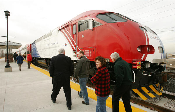 Salt Lake-area civic leaders, community leaders, and media representatives board FrontRunner train for special demonstration trip in October 2007.
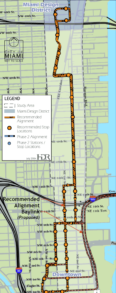
 Miami's proposed modern streetcar is expected to attract more passengers than bus and stimulate economic development.
 Grand Rapids streetcar: Original electric streetcar system was early victim of Transit Holocaust in mid-1930s.
 With 11 stops, located approximately every 2-3 blocks, and three modern, articulated Czech-made
streetcars, the initial line will link Seattle's Westlake Center to the city's rapidly growing South Lake
Union redevelopment area.
Approximately $50.5 million is budgeted for the line's capital investment – calculating to a unit
cost of about $39 million per mile ($24 million/km).
With 11 stops, located approximately every 2-3 blocks, and three modern, articulated Czech-made
streetcars, the initial line will link Seattle's Westlake Center to the city's rapidly growing South Lake
Union redevelopment area.
Approximately $50.5 million is budgeted for the line's capital investment – calculating to a unit
cost of about $39 million per mile ($24 million/km).
 Roanoke streetcar: Roanoke Railway & Electric streetcar system once spanned the city with approximately 80 miles of track before it was abandoned and destroyed in the Transit Holocaust.
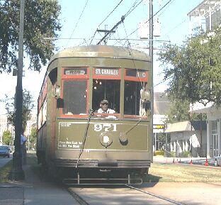 According to an RTA media release, on that date, "before the sun rises, the historic Perley Thomas
streetcars will once again proudly traverse St. Charles Avenue, from the Central Business District,
through the picturesque Garden District to Napoleon Avenue."
RTA also notes that, after the Lee Circle/Howard Avenue stop, "car stops along the line are located
on the neutral ground and are all labeled."
According to an RTA media release, on that date, "before the sun rises, the historic Perley Thomas
streetcars will once again proudly traverse St. Charles Avenue, from the Central Business District,
through the picturesque Garden District to Napoleon Avenue."
RTA also notes that, after the Lee Circle/Howard Avenue stop, "car stops along the line are located
on the neutral ground and are all labeled."