Light Rail Now and Walkable Neighborhoods (LRN) can be contacted at: Light Rail Now! |
Special Note: Since this article was originally posted, Seattle's light rail project has been substantially revised. See the story at Seattle's Light Rail Project Reborn as South Starter Line.
Transit alternatives? So far, it's mainly been ... buses in bumper-to-bumper traffic, and buses lumbering through roadways in air filled with exhaust fumes from motor vehicles. But that's going to change, if a voter-approved and officially sponsored light rail transit (LRT) conception – called Link – can be brought to reality. By 2010, according to current plans, more than 20 miles of a north-south "spine" LRT line will carry some 120,000 riders a day. While trains would travel up to 55 mph maximum speed, with station stops the schedule speed would average between 25 to 28 mph – definitely competitive with the 20-25 mph average experienced on Seattle's crowded roadways. Seattle mobility costs big bucks Seattle and Tacoma area voters gave the green light to light rail back in 1996, when they overwhelmingly approved a multi-modal plan called Sound Move which includes bus service improvements and commuter rail as well as LRT. Certainly, the Link project is expensive – probably the most expensive LRT project yet in the USA. The latest analysis estimates a total cost of $3.6 billion – about $171 million per mile. Why? Well, Seattle is certainly one of the most expensive urban areas to build any kind of transportation facility. To the hilly terrain and numerous waterways, plus the constraint of the Pacific Ocean (Puget Sound) on one side, you can add compacted, densely populated, well-established neighborhoods. On top of all that, include environmental challenges (e.g., protecting salmon, preserving spectacular scenic vistas, etc.) and you've got a recipe for high cost and easily unforeseen engineering pitfalls. If you think Link light rail is expensive, well, just consider freeway construction in the area. Widening and rehabilitating interstate Highway 405 from the suburban communities of Lynnwood to Tukwila – 33 miles of freeway – is projected to cost $7 billion. That's about $212 million per mile – and just for upgrading an existing roadway facility. The Link LRT project would provide a totally brand-new rapid transit facility straight through the heart of the city, including its most heavily populated and congested areas. in contrast, Link starts to sound like a bargain. High capacity, heavy cost
While Link is conceived as LRT, in many respects it's fairly close to full rapid transit – certainly, on the "high" or "heavy" end of the LRT spectrum in terms of capacity and design. One indication of the extraordinary capacity demand on the system is its power requirement.
While LRT lines traditionally have been electrified at 600 to 750 volts direct current (VDC), Link's being planned for 1500 VDC – the first North American LRT line of that high a voltage since World War 2. Compatibility with neighborhoods, environment And the line will include approximately 4.5 miles of tunnel, most likely including a tunnel under the Portage Bay ship channel. Why so much tunnel? Short answer: it's what Seattle residents want. Certainly, an LRT system could be built on the surface, or – if it needs to be totally separated from other traffic – in an aerial, or elevated, alignment. But Sound Transit, the Seattle transit agency in charge of the project, has gone through years of study and dozens upon dozens of community meetings designed to get public input and to fine-tune the project in response to community desires. Neighborhhoods have made it clear they don't want elevated structures of any kind shadowing their streets and homes and interrupting scenic vistas. Furthermore, there are daunting environmental challenges ... such as crossing Portage Bay. Engineering a crossing is the least of the project's problems. Portage Bay is a habitat of Chinook salmon, listed as an endangered species. Any transportation facility negotiating a crossing of the waterway must deal with the problem of protecting these salmon. A bridge has the additional liability of triggering opposition from adjacent neighborhoods. Sound Transit's favored solution is a very deep – and very expensive – tunnel under the waterway. Through the University area north of the ship channel, the Central Link line would be routed in tunnel. This would continue beneath the waterway and on southward, beneath the Montlake residential neighborhood area, into the geologically formidable Capitol Hill/First Hill area. Why not an elevated alignment through these neighborhoods? Forget it. Any above-ground alignment through this area is described as a "political non-starter". Linking north and south Then, still underground, the LRT line would turn westward into downtown Seattle, travelling into the existing Downtown Seattle Transit Tunnel currently used by electric trolleybuses, thus serving the several existing stations already in place.
When it's completed, the Central Link LRT route will enable Seattle-area travellers as far north as Northgate to hop on board a light rail train and then relax as they cruise past the miles of almost-solid brake lights (of the bumper-to-bumper traffic on adjacent roadways) on their way to the University of Washington or downtown Seattle, or all the way to SeaTac international Airport. According to the Link Final Environmental impact Statement (FEIS), the total travel time to Northgate is about 50 minutes for a distance of about 23 miles, which works out to about 28 miles per hour; a more recent engineering update calculates a travel time of 53 minutes, or about 25-26 mph. Either way, it will be one of the fastest LRT lines in the world. Even through the predominantly street-routed Rainier Valley segment, south of downtown, the projected Link LRT travel time is 10.5 minutes over about 4.6 miles, or more than 26 miles per hour. As the local pro-transit group People for Modern Transit (PMT) points out, "This beats freeway gridlock any day and is far faster than most buses." Dramatic impact on traffic flow About 2/3 of Link's riders will come from existing buses. But they'll be getting a much better, faster, safer, more comfortable, and more reliable ride, at a lower subsidy (50% vs. 75% for buses), and saving travel time (an average of 5 to 8 minutes one way). This increase in "mobility" is, in fact, the major purpose of the light rail system – as well as exerting significant influence of land-use patterns. As the Sound Move plan states, "The high-capacity transit system's purpose is to improve mobility within the urban areas by providing travel alternatives so they may grow comfortably while preserving rural areas for future generations." Thus, Link LRT is not intended just to be a commuter transit system. However, it will have a dramatic impact on traffic flow, with fully 1/3 of its ridership – about 36,000 passenger-trips a day – expected to be totally new riders, mostly from automobiles. Certainly, this amount of traffic is quite small in comparison with the vastness of Seattle's entire regional traffic – but why try to compare traffic improvements in a single corridor with travel volumes of the entire region? if that were routinely used as a basis for evaluating projects, not a single bridge, underpass, tunnel, or freeway would ever get built. But in the corridor served by the light rail route itself, Link will make a major difference, especially since this route parallels interstate Highway 5 at its most constricted segment. Thus, light rail will take 16,000 cars a day off Seattle's jammed roads, more than one clogged freeway lane for the entire length of Seattle. Over time, many more new riders are expected to be attracted to LRT as a result of the superior level of service. Slowing growth of congestion
Over a longer term, the goal of new LRT systems like Link is to change the "automobile culture" by forging a regionwide rapid transit system with an intermeshing network of local and feeder transit plus a major push to foster transit-oriented development – commercial and residential real estate development adjacent to the transit stations. Clustering development helps to attenuate the "sprawl" effect, and at the same time boosts transit ridership by "building in" a base of clustered population with a greater tendency to use the system. Even increasing transit ridership from the current 3% to just 6% of regional trips, as projected by Seattle planners, would be a major accomplishment for the system envisioned with Link light rail. However, LRT supporters expect the Link strategy to do far better in the long run, especially when Seattle motorists are forced to confront mitigation measures for global warming and the ballooning costs of energy brought on by dwindling global oil supplies. Providing real alternative to traffic By serving high-density neighborhoods directly, Link will enable large numbers of people to walk to the LRT stations. Many others will be able to take a short bike or bus ride. This is what leads to the huge ridership – more than 100,000 a day – that's far in excess of ridership on all other recent light rail lines in the country. This is why commuter-oriented proposals such as HOV lanes and the "freeway monorail" system touted by LRT opponents would have such low ridership – they specifically avoid accessing and serving Seattle's neighborhoods! Extended throughout the Seattle-Tacoma region, Link will give people real alternatives, especially to congested freeways. Most regional car
trips (about 85%) are non-commuter trips, often local (like a short hop to the grocery store); compared with millions of these daily car trips,
transit ridership tends to seem minuscule, and its importance is often underestimated. But when fully built out, Link could be transporting
the equivalent of more than 7 freeway lanes of traffic through the downtown bus tunnel. This sure beats building freeways incessantly. Cost increase spurs "snake-oil" alternatives LRT was selected as the best transit mode choice for Seattle after years of thorough, arduous, exhaustive, detailed examination and assessment of alternatives, which evaluated "heavy" rail rapid transit, monorail, maglev, Personal Rapid Transit, Automated Guideway Transit, busways, Bus Rapid Transit, HOV lanes, and other mass transit options. in this analysis, LRT proved superior in every respect – cost-effectiveness, ridership, technical flexibility, environmental impact, and many other aspects. in the campaign leading up to the popular vote in 1996, LRT opponents paraded a grab-bag of the same stale "alternatives", claiming they were better and should be "studied" further. But an array of previous planning studies had concluded that to meet transit needs in the Seattle core, light rail was the clear choice in terms of performance and versatility. Accordingly, in 1996, voters rejected the opponents and their hodgepodge of "better" alternatives, and resoundingly gave the green light to the Link LRT plan. But a development late in 2000 has breathed new vigor into opponents of Sound Transit's Link LRT plan. in November 2000, top officials of Sound Transit announced that – particularly because of unexpected tunnel engineering challenges – the cost of the Link project would increase by about 35%, and completion would be delayed by three years. Opponents, hoping to kill the LRT plan or at least further delay a rail solution to the Seattle region's mobility problems, have emerged from obscurity, brandishing anew a higgledy-piggledy assortment of "remedies" like snake-oil salesmen. Two purported alternatives have garnered most of the limelight: (1) Monorails and (2) Free buses. But both alternatives – already evaluated and rejected in previous analysis by area planners – have serious problems. Proponents of both appear to be ridiculously lowballing their purported costs, while wildly exaggerating claims of ridership (without the systematic ridership forecasting process used to predict Link LRT ridership). Meanwhile, backers of each scheme also seem to be contradicting each other in their arguments and claims. Monorail dreams ... real-world nightmare Monorail advocates, for example, assert that surface transit is undesirable, and that elevated transit – of the monorail variety – should be built, mainly following freeway routes. Bus zealots, on the other hand, argue that fixed-guideway systems (of which monorail is an example) are inflexible and unaffordably expensive. However, virtually all LRT opponents have tended to bury these stark differences, temporarily, and to unite within their campaign to scuttle LRT. Seattle planners have long since rejected either alternative, and for solid reasons – mainly based on real-world experience. Despite claims by proponents lowballing costs, monorail systems are substantially more expensive (they must be totally elevated). LRT can likewise be elevated, but Seattle residents and business owners, in numerous community meetings, have made it clear they don't want elevated structures of any kind – mororail or light rail – shadowing their streets and homes and obscuring scenic views. As the pro-LRT People for Modern Transit group has noted, "The advantage that monorail advocates have is that they haven't had to take their plans out into the neighborhoods." Monorails additionally have technical drawbacks. Switching from one beam or track to another – a common requirement in any complex, heavy-duty urban transit system – is relatively slow and cumbersome. Since monorails run on rubber tires, operation in icy or wet conditions can present problems. And providing storage and maintenance facilities for a large fleet of monorail vehicles, straddling or hanging from huge concrete or metal guidebeams, is an enormous headache. No wonder most transit operators don't walk, they run away from monorail systems! "Free bus" plan: turning lead into gold? The other major alternative to LRT being touted – a no-fare bus plan dubbed "Ride Free Express" – likewise is rife with drawbacks. Essentially, the proposal would deplete capital funds by diverting them into operations to make up for the lost farebox revenue. Like monorail zealots, "Ride Free" proponents blithely lowball the costs of their alternative and exaggerate potential ridership. Reminiscent of medieval alchemists who claimed to turn lead into gold, "Ride Free" boosters rely on numerical sleight-of-hand and the naivete of their audience. Actual experience, such as that in Austin, Texas in the early 1990s, suggests that operating costs balloon (to make up for lost fares while providing extra capacity) while ridership increases only modestly (perhaps 10-11%) ... and most of the new riders are existing riders just making more trips, not motorists attracted from cars! Critics also argue that vagrants, truant schoolchildren, and similar "problem" riders tend to repel commuters and other "bread and butter" passengers. One might ask: if a free-fare system were so cost-effective and successful, why has not one single major transit agency anywhere in the world adopted it on a permanent, ongoing basis? "After five years of running such a system and driving away some passengers, our agencies would have spent the money and free-bus service would be scrapped" says PMT. "We would be right back where we are now except with worse traffic, no light rail and no funding to build anything." A bargain for the future Sound Transit and supporters of the Link LRT plan should hang in there, say LRT proponents, and stay with the LRT project – because it will pay off abundantly in the long run, even with the higher budgeted cost. Besides, many large transportation projects encounter cost increases or budget overruns. The cost of a third runway for SeaTac Airport, for example, originally budgeted at $229 million in 1992, had ballooned to $773 million by 1999. As a letter to the Seattle Times argues: The roads aren't getting any better. An additional three years to build the existing plan? As if we think going back to the drawing board - or better yet, trying to get this voted on again - is going to improve that timeline? Arrrggghh! The bottom line, say LRT supporters, is that it's time to bite the bullet and go forward with an investment in high quality light rail transit to serve many generations to come. Much of this report has been adapted from materials provided by Sound Transit and People for Modern Transit.
Support Link light rail for Seattle! |
|
|
|
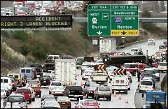 Bumper-to-bumper traffic ... Air filled with exhaust fumes from motor
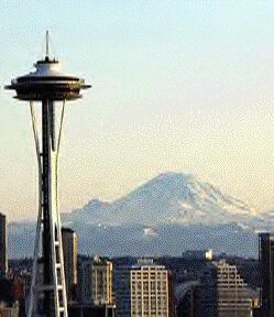
vehicles. Narrow traffic corridors constrained by hilly terrain, waterways, and the coastline of Puget Sound (an inlet of the Pacific Ocean) – that's what most urban travellers in Seattle are facing today.
Bumper-to-bumper traffic ... Air filled with exhaust fumes from motor
vehicles. Narrow traffic corridors constrained by hilly terrain, waterways, and the coastline of Puget Sound (an inlet of the Pacific Ocean) – that's what most urban travellers in Seattle are facing today. 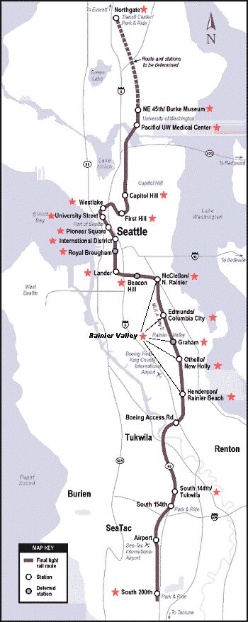 The initial phase of the Central Link LRT project would span most of the length of urban Seattle – from the Northgate area in the north to the SeaTac Airport area in the south.
That's a total of 24 miles. Currently, about 21 miles are included in the $3.6 billion cost estimate (from NE 45 St. In the University of Washington area to SeaTac), so Sound Transit is currently probing ways to finance the additional $400 million or so needed to extend Link the additional 3 miles north to the Northgate area. An array of 23 stations is ultimately planned for the final 24-mile line.
The initial phase of the Central Link LRT project would span most of the length of urban Seattle – from the Northgate area in the north to the SeaTac Airport area in the south.
That's a total of 24 miles. Currently, about 21 miles are included in the $3.6 billion cost estimate (from NE 45 St. In the University of Washington area to SeaTac), so Sound Transit is currently probing ways to finance the additional $400 million or so needed to extend Link the additional 3 miles north to the Northgate area. An array of 23 stations is ultimately planned for the final 24-mile line.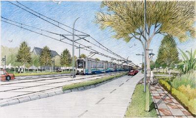 South of downtown, the LRT line would come to the surface and proceed on south, through the Rainier Valley area, in both surface and aerial alignments.
Many surface routings would take the form of segregated alignments in existing thoroughfares – providing a more accessible and visible facility for surrounding neighborhoods, and a more pleasantly scenic ride for passengers.
(it should be noted that Rainier Valley communities opted for surface light rail because of the greater potential of transit-oriented development. Area residents have in mind to create new
town centers around the light rail stations.)
South of downtown, the LRT line would come to the surface and proceed on south, through the Rainier Valley area, in both surface and aerial alignments.
Many surface routings would take the form of segregated alignments in existing thoroughfares – providing a more accessible and visible facility for surrounding neighborhoods, and a more pleasantly scenic ride for passengers.
(it should be noted that Rainier Valley communities opted for surface light rail because of the greater potential of transit-oriented development. Area residents have in mind to create new
town centers around the light rail stations.)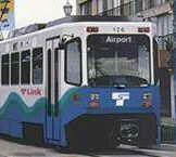 it's important to note that 24 miles of LRT – or even a hundred miles – will not, in and of itself, stop the growth of traffic congestion. However, LRT has shown in other cities that it has the potential for at least slowing the growth of overall congestion, providing an alternative to congested car and bus traffic, and representing the initial steps in building a future system which can impact overall congestion. in other words, growth in congestion will be slowed along specific Link routes, but LRT alone won't be enough to overcome current growth rates in car travel.